
Vueron Newsletter
No. 13
2023.05.16
| Seoul Robotics unveils 3D perception-based intersection solution | ||
| Perrone Robotics rolling out self-driving shuttle program for colleges and universities | ||
| First high definition 3D maps of Waikato released | ||
1. Seoul Robotics unveils 3D perception-based intersection solution
-
-
Seoul Robotics unveiled their latest solution, an end-to-end intersection traffic solution, using their SENSR-I 3D perception platform developed specifically for infrastructure.
-
The solution transforms raw 3D data into actionable insights for traffic controllers to interpret real-time data to help drive roadway decisions beyond traditional traffic control measures.
-
SENSR platform combines 3D perception technology mostly lidar and AI to drive real-time decision-making on the road, detecting pedestrians, cyclists, and vehicles approaching an intersection and sending signals to the traffic controller that crossing is happening.
-
The system can track real-time movement across an intersection and can send signals to the traffic controller to delay the signal from changing, making crossings safer for pedestrians, particularly for those with disabilities or are older.
-
This solution is particularly important for cities to meet their climate goals in part by becoming less car-dependent and more pedestrian-friendly, making things safer, and avoiding danger situations at intersections.
-
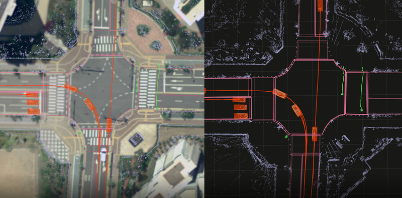
As many cities across the United States are looking to meet their climate goals in part by becoming less car-dependent and more pedestrian-friendly, this solution can make things safer and avoid danger situations at intersections. The detection technology does not collect personal and biometric data on individuals, making it more efficient and safe for users.
2. Perrone Robotics rolling out self-driving shuttle program for colleges and universities
-
-
Perrone Robotics announced that it will be rolling out a self-driving shuttle program at several colleges and universities, starting with Virginia Tech in Blacksburg.
-
The shuttle program is designed to help with transportation needs around campuses, reducing emissions, and increasing safety.
-
Perrone Robotics’ autonomous shuttle is fully electric and can operate for up to 10 hours on a single charge.
-
The shuttle has a maximum speed of 25 miles per hour and can accommodate up to six passengers.
-
The shuttle has a human backup driver who can take over control if needed, and the shuttle is equipped with various sensors, cameras, and other safety features.
-
The autonomous shuttle program is part of a larger initiative to increase the use of autonomous vehicles in various settings, including public transportation and commercial delivery.
-
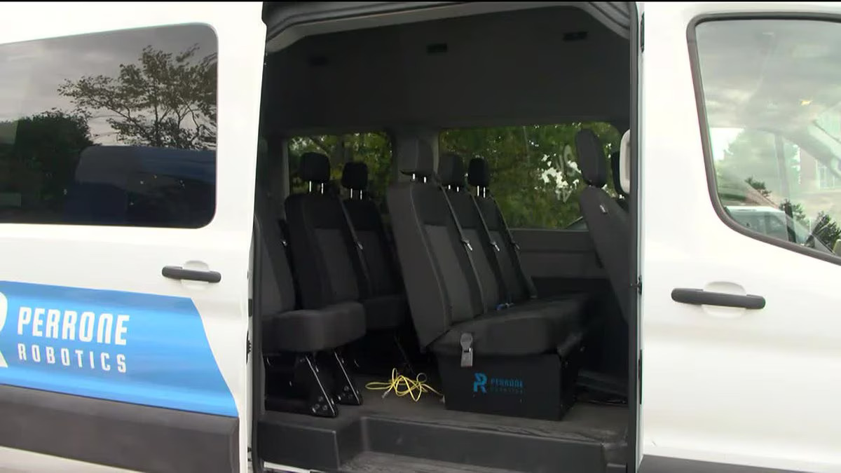
The autonomous shuttle program is part of a larger initiative to increase the use of autonomous vehicles in various settings, including public transportation and commercial delivery. This program is expected to provide a safer and more efficient transportation option to students and faculty, reducing congestion and making campus travel more convenient.
3. UK to roll out first driverless bus service
-
- The UK will launch its first driverless bus service in Cambridge in the next few weeks.
- The autonomous bus will operate on a route of around 2.5 miles (4 km) and will connect the city center with the city’s science park.
- The bus will be equipped with sensors and cameras, and will have a safety driver on board who can take control if needed.
- The driverless bus is a project led by the UK government, which aims to showcase the country’s expertise in autonomous vehicle technology.
- The project is being run by the Center for Connected and Autonomous Vehicles (CCAV) in partnership with several private companies.
- The deployment of the driverless bus is part of a wider push to develop and commercialize autonomous vehicle technology in the UK.
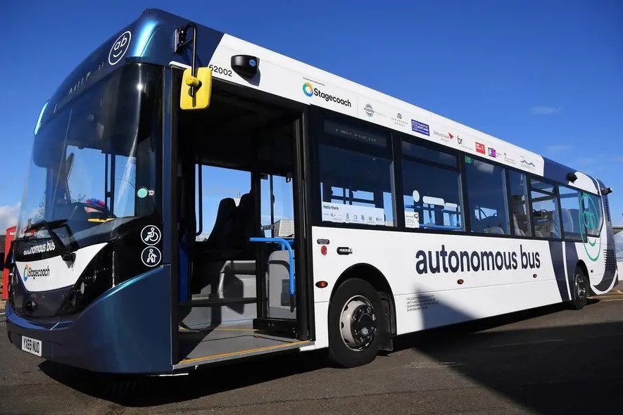
The project is being led by the UK government and is part of a wider push to develop and commercialize autonomous vehicle technology in the country. This driverless bus service is expected to improve the transportation system in Cambridge, providing a convenient and eco-friendly option for commuters. It will also demonstrate the country’s expertise in autonomous vehicle technology, potentially boosting its reputation as a leader in the field.
4. First high definition 3D maps of Waikato released
-
-
A New Zealand-based technology firm, Augview, has released high-definition 3D maps of Waikato, a region in the country, using LiDAR technology.
-
The LiDAR technology enables the creation of precise and accurate 3D maps that can help in better planning of infrastructure projects, reducing the risk of errors and rework, and minimizing disruptions to communities.
-
The 3D maps are intended to be used by local authorities, infrastructure providers, and utility companies to better understand the geography of the region and plan their projects accordingly.
-
Augview’s augmented reality platform allows users to overlay digital information on top of the real world, making the 3D maps interactive and more informative.
-
The Waikato Regional Council is the first local authority to use Augview’s 3D mapping technology, with other councils and utility companies expected to follow suit.
-
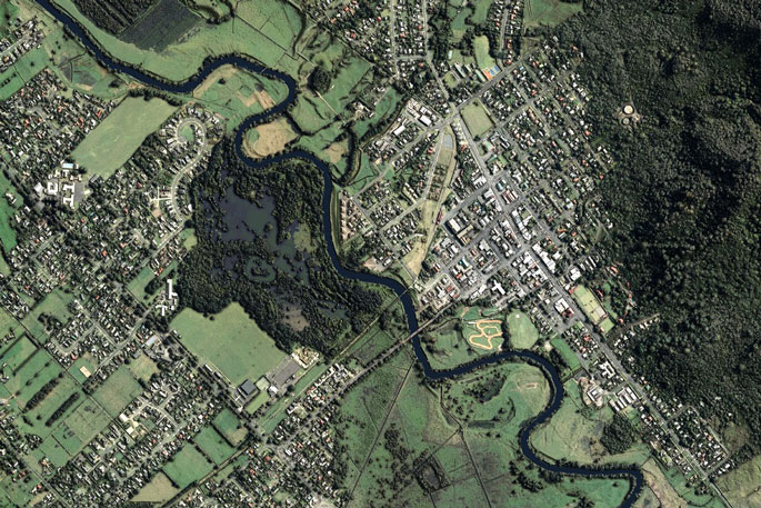
The LiDAR technology enables the creation of precise and accurate 3D maps that can help in better planning of infrastructure projects, reducing the risk of errors and rework, and minimizing disruptions to communities. LiDAR technology is becoming increasingly popular in the field of mapping and surveying due to its high level of accuracy and precision. The use of LiDAR technology in creating 3D maps is expected to be a key driver in the development of smart city projects and other infrastructure projects in the future. The Waikato Regional Council’s use of Augview’s 3D mapping technology is a promising sign of the potential of LiDAR technology in the field of urban planning and infrastructure development.
5. U.S. trade panel votes to investigate lidar tech company Ouster’s patent suit against rival Hesai
-
- Ouster has filed a patent complaint against Chinese rival Hesai Group.
- The US International Trade Commission has voted to investigate the complaint.
- An administrative law judge will schedule a hearing into Ouster’s request for a ban on allegedly infringing Hesai products.
- Ouster claimed in its suit that Hesai incorporated its digital lidar technology in the company’s sensors.
- The investigation could lead to a ban on Hesai’s lidar sensors in the US market.
This is another example of the ongoing patent battles in the lidar industry, which is becoming increasingly competitive as more companies enter the market. The outcome of the investigation could have significant implications for Hesai’s business in the US, as it may be prevented from importing and selling its lidar sensors if found to be infringing Ouster’s patents. It also highlights the importance of protecting intellectual property in emerging industries like lidar, where technological innovations are rapidly advancing.
*Contents above are the opinion of ChatGPT, not an individual nor company